The Best of Creative Computing Volume 1 (published 1976)
Weather Forecasting Applications (Naval Environmental Display Station Speeds Weather Forecasts, 1971 ultraviolet image from Orbiting Solar Observatory-7)
Navy display speeds weather forecasts
A communications and display system in prototype operation at the Navy's Fleet
Numerical Weather Central in Monterey, Calif., is expected to improve and speed
weather forecasts dramatically.
Developed by Genisco Technology Corp., Compton, Calif., the Naval Environmental
Display Station (NEDS) provides full communications, remote processing,
automatic graphic storage, retrieval and TV display capability up to 80 data
bits. The system incorporates a special data-compression technique that permits
the Naval Weather Service to use the existing Teletype netowrk for transmitting
weather and oceanographic data to the fleet.
Weather conditions are observed on a CRT display of the Naval Environmental
Display Station now under test at Monterey, Calif.
Traditionally the service uses facsimile equipment to transmit graphic data over
costly, wideband transmission lines. Weather and oceanographic maps received
over the system often are of poor quality and difficult to interpret.
Correlation is done manually, and it involves the overlaying of maps by hand to
make predictions.
The system being tested has two TV monitors and a keyboard that permits a
forecaster to view alphanumeric and color graphic material, while a
plotter/printer makes copies of any material of interest.
All data received, selected and stored are automatically logged into a computer
index and become available, upon demand to the forecaster. He can call for a CRT
display of the index, which lists the weather maps, messages and other data in
the system's disc storage. He then calls for a display of the desired weather
maps, via the keyboard, to do his forecast.
***
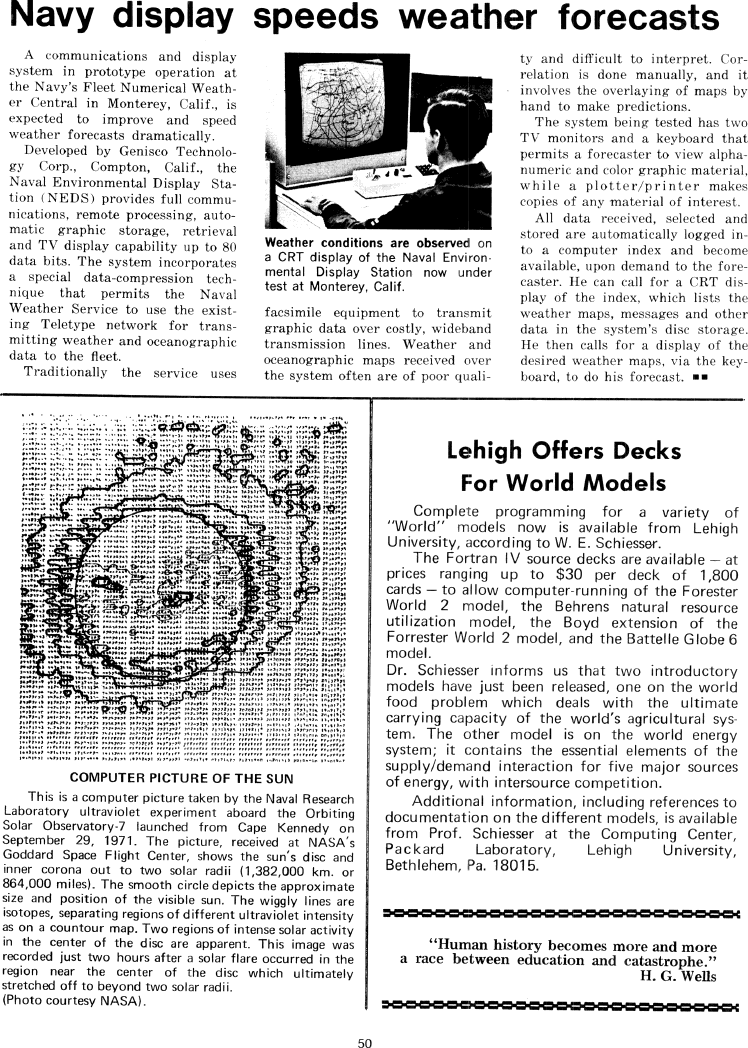
Computer picture of the sun
This is a computer picture taken by the Naval Research Laboratory ultraviolet
experiment aboard the orbiting Solar Observatory-7 launched from Cape Kennedy on
September 29, 1971. The picture, received at NASA's Goddard Space Flight Center,
shows the sun's disc and inner corona out to two solar radii (1,382,000 km. or
864,000 miles). The smooth circle depicts the approximate size and position of
the visible sun. The wiggly lines are isotopes, separating regions of different
ultraviolet intensity as on a contour map. Two regions of intense solar activity
in the center of the disc are apparent. This image was recorded just two house
after a solar flare occurred in the region near the center of the disc which
ultimately stretched off to beyond two solar radii.
(Photo courtesy NASA).
***
Lehigh Offers Decks For World Models
Complete programming for a variety of "World" models is now available from
Lehigh University, according to W. E. Schiesser.
The Fortran IV source decks are available -- at prices ranging up to $30 per
deck of 1,800 cards -- to allow computer-running of the Forester World 2 model,
the Behrens natural resources utilization model, the Boyd extension of the
Forrester World 2 model, and the Battelle Globe 6 model.
Dr. Schiesser informs us that two introductory models have just been released,
one on the world food problem which deals with the ultimate carrying capacity of
the world's agricultural system. The other model is on the world energy system;
it contains the essential elements of the supply/demand interaction for five
major sources of energy, with intersource competition.
Additional information, including refereces to documentation on the different
models, is available from Prof. Schiesser at the Computing Center, Packard
Laboratory, Lehigh University, Bethlehem, Pa. 18015.
***
"Human history becomes more and more a race between education and catastrophe."
-- H. G. Wells